The Butler Trek to Georgia - 1785 By Randy Wilson
First, I want to say that a lot of what I am writing here is pure speculation and imagination. Anyone reading this that has corrections or additional information, please let me know so I can amend this story. I expect I will be adding to this for years as I learn more.
For several years I have been researching the Butlers of Hanover VA. I had made a previous trip to Hanover and one to Mecklenburg County and after reading up on the family move to GA I knew I wanted to try and retrace some of the route. My intent here is to write down and preserve the accomplishment of some of my distant ancestors. The distance they traveled is huge. This trip, for its time, was equal to the trip made 75 years later when trains went overland to California.
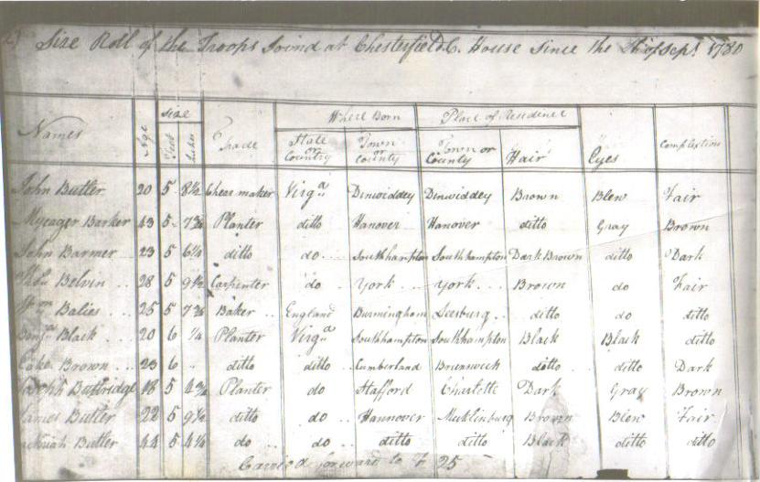
Zachariah Butler farmed first near Hanover, VA and later moved to Mecklenburg County VA. There, he and his sons enlisted in the army and fought in the Revolutionary War. After the war, in 1785, he and ( at least ) two sons, Patrick and James, moved to GA. That trek of about 425 miles would take them on a journey that had to be rugged and it had to be extremely difficult. Most likely, the train they would have formed would have been a grouping of several families. The exact number is not known, but it was commonplace for a train of several families to gather and travel together for obvious reasons. The labor in moving heavy wagons and herding livestock required that the numbers of able bodied men be of sufficient size that they could handle all the work and also provide security.
When the trek took place: What we know is very limited. We have no diary so about all we can do is speculate. Zachariah and his wife sold some of their property in Nov of 1784 and that is probably a good way of calculating when they began readying for the trip. It would have taken months to accumulate the needed supplies, wagons, and mules or oxen. Many man-hours of accumulating the necessary tools, equipment, food, seed, clothing, animals, medicine, house wares, etc would be needed. Someday we may come across some other family’s diary of the same trip and that may shed some light on the journey. We know that Zachariah registered his deed for his land in Georgia in August of 1785. I think he must have registered his deed in Dartmouth or Petersburg, GA. So, somewhere in between they actually made the trip. The journey was about 425 miles and it would have taken 2-4 months to make the trip. A lot depends on how loaded the wagons were and what the weather was like. Once they made the decision to go I am sure they would have struck out just as soon as they felt they could safely travel. Knowing they would encounter many river crossings and that rain and wind could drastically impact their health, I doubt they would have left much before late March . James Butler had two very small children ( Zachariah -age 3 and Walk- an infant ) according to the records I have been able to locate. That would be a consideration. Zachariah Butler’s youngest daughter was about 14 on this trip - no doubt she talked about the trip for the rest of her life.
Interesting note about Conestoga wagons that I did not know. Late 1700’s Conestoga wagons did not have a seat on the front of the wagon to ride on and control the animals with reins. Wagon was controlled by a rider on one of the animal’s back or by someone walking with the lead animal in hand. Take a close look at the above old drawing.
One of the reasons I became interested in learning more about this trek is because several years ago I read a book, UNDAUNTED COURAGE , by Stephen Ambrose. It is an account of the Lewis and Clark expedition in 1803. Young Meriwether Lewis’s stepfather was a veteran of the Revolutionary War and he too made a trek to Georgia in 1782, right after the war was over. The trek that the Butlers made in 1785 is probably the exact same trek that Meriwether Lewis made in 1782 (+/-) at the age of 8 or 9. Stephen Ambrose wrote in UNDAUNTED COURAGE the following paragraph and I think it is totally applicable to the experience that the Butler ( men ,women and children ) experienced.
“Few details of this trek into the wilderness survive, but it is easy enough to imagine a wide-eyed boy on the march with horses, cattle, oxen, pigs, dogs, wagons, slaves, other children, adults -making camp every night - hunting for deer, turkey, and possum; fishing in the streams running across the route of march, watching and perhaps helping with the cooking; packing up each morning and striking out again; crossing through the Carolinas along the eastern edge of the mountains; getting a sense of the vastness of the country, and growing comfortable with life in the wilderness.”

The trail they would have traveled is probably the Fall Line Road. Without a diary we can only speculate, but odds are they used that trail. It had been in existence for some time and no doubt they had spoken to many travelers who had used it. James and Patrick, through their Revolutionary War experience, had traveled some and were probably familiar with the terrain as far south as Camden, SC where it is said that one or both sons may have fought in the Battle of Camden ( 1780 ) five years earlier. There they would have spoken with many other men who had been to GA. The Fall Line Road came through VA and passed just a little east of Mecklenburg County. It ran from Richmond VA through Petersburg VA, Warrenton NC, Raleigh NC, Cheraw SC, Camden SC, Columbia SC, ending in Augusta GA. I actually think they left the Fall Line Rd around Camden SC and traveled due west to Ninety Six and Abbeville and then cut southwest to the river crossing of the Savannah River at Petersburg GA. Petersburg GA was at the confluence of the Savannah and Broad River, N33 57' 48 W82 34' 13 . The crossing at Petersburg is also about 9 miles from the land they settled, so I am convinced this is where they crossed, not at Augusta.

We visited a museum run by the US Army Corps of Engineers on the Richard Russell Lake and they had a map showing a trail used by colonists going from Camden, SC to Abbeville, SC and then down to Petersburg, GA.
A map showing the route I think they took.
Initially I had calculated that a trip of 425 miles would take 4-6weeks assuming about 15 miles per day.
My wife and I picked up the trail in Apex NC just south of Raleigh NC. Right away I was impressed at how many water crossings we encountered. Rewind 200+ years and imagine doing all the water crossings in wagons and with livestock - that forces you to recalculate how long it would take to make a trip of 425 miles. I assume that Zachariah, James and Patrick formed a nucleus for a larger train that moved from Mecklenburg VA to Wilkes County GA in early 1785. The train could only move as fast as the slowest wagon and that is all dependent on who carried the heaviest load or had the weakest team of mules/oxen. Also, livestock herding and taking care of small children would certainly have an impact. In many places I can imagine where they would have to stop and combine two or more teams of mules/oxen to get a single wagon up the far side of some inclines. After seeing firsthand some of the water crossings, the density of the brush and the steepness coming out of some of the valleys and gullies, I began to rethink the time it would take. I have no way of knowing until I find a firsthand diary, but for now I am thinking they would do well to average 40-50 miles per week. That would then equal 9-11 weeks of travel. Maybe more maybe less. If they departed the first week of April they would arrive in GA about mid June - early July. Zachariah recorded his deed on Aug 2nd 1785 so that is about right. But, every day on the trail is a DAY NOT FARMING AND GETTING READY FOR SPRING of 1786. It had to be on Zachariah’s, James’ and Patrick’s minds that they needed to get where they were going and clear land, build shelters and prepare for winter. Very heavy responsibility.
Driving down Hwy 1 - a road through a wilderness 225 years ago. Zachariah Butler was 49 years old at the time.
Imagine topping a hill and heading down toward an unnamed river and having to do a water crossing. The bridges we take for granted move us over a river in seconds that may have halted the wagons for days.
DEEP WATER ! ! !
Side trip:
There was a thriving business in colonial America known a “Ferries.” And they played an important role in moving people and materials over large rivers and bays. Zachariah Butler is said to have spent the better part of his enlistment during the Revolutionary War guarding an important ferry crossing on the Roanoke River called Taylor’s Ferry and I still have some research to do on it. If I am not mistaken it was located about: N36 35 34.84 W 78 25 22.77
A pretty good account of the importance of the various ferries can be found in reading about the retreat of Gen Nathanael Greene. ( yes, that is how his first name is spelled )
The British lost the race as well as any hope to control the Southern Theater. Cornwallis had been outgeneraled in being attracted too far in an unsuccessful pursuit. Luring the British troops far from their supply base in Charleston SC, the Colonists raced with Cornwallis in hot pursuit to the Dan River. Greene's troops crossed in pre-positioned ferries and boats only hours ahead of the British light calvary. Without boats, the stranded and frustrated British retreated to Hillsborough NC. Greene used the next few days in Hallifax County Va to gather new troops, needed supplies and horses in preparation for a planned, direct encounter with the redcoats.
"This American retreat, which extended across the breadth of NC is considered one of the masterful military achievements of all time." Dennis M. Conrad Project Director & Editor, The Papers of General Nathanael Greene
( The Dan River and ferry was just upstream from Taylor’s Ferry )
What is interesting to note is that Gen Greene directed Lt. Col Edward Carrington to survey several rivers and ferries. Lt. Col Carrington was stationed at Taylor’s Ferry - same place Zachariah Butler was stationed.
If you want to read more, copy and paste the following in your browser. This is excellent reading.
ttp://www.prizery.com/index.php?option=com_content&view=article&id=139&Itemid=222
And scroll down to the heading THE FORTUNATE SURVEYING OF THE DAN RIVER
This will take you on a thrilling tour of Gen Greene’s retreat and then on to a subsequent battle at Guilford Courthouse that Patrick Butler is said to have participated in. I don’t know about anyone else, but when I read history now it has a different meaning to me now that I am related to someone who was in the thick of it.
Back to the Butler Trek:
It is difficult to see in this photo, but in a part of southern NC and northern SC there is deep sand that was once an ancient beach, part of a long ago ocean that left dunes for miles and miles. You have walked along a beach and you know how easy it is to bog down - imagine taking a wagon through 125 miles of sand. Granted, I am sure that previous travelers had done much to make the worst sections more passable, but I am quite sure there were very difficult days on that terrain.

Today it is a nice road with an elevated roadbed. If you look to the left you can see the sand just barely covered with scraggly grass. Right about here I bet our ancestors all had reservations about this trip - but you can’t stop here as the soil is terrible for farming. It is, however, wonderful for golf courses, and near Southern Pines NC there are golf courses galore. Pinehurst is there and it is home to some major PGA golf tournaments. The same soil that is lousy for wagon trains is perfectly suited for a golf course- when it rains the water never puddles on the course. It percolates down quickly and players can continue to play
SC: Cheraw to Abbeville
Crossing into SC it is more of the same. Sandy, poor soil, low pine trees, and even more rivers to cross. It is unknown how many of the larger rivers had ferries, what they charged, or if the Butlers used them. I am sure there were very few places to resupply. Cheraw SC was certainly in existence in 1785 and no doubt would have been a resupply point. Further west Camden would have been one and west of there a village of Ninety Six would have been a supply point.
We stopped at the US National Park Service National Historic Site of Ninety Six and were well rewarded. It is a very worthwhile stop. There were two Revolutionary War battles at Ninety Six. One in 1775 and one in 1781 - as a result the townspeople moved a few miles to a new location and that would probably be where the Butler train would have passed.
But, the National Historic site is well worth a visit. I highly recommend. There is a place back near the old star fort where you can see the wagon ruts that were churned up by the passing traffic on the Island Ford Rd. It is absolutely stunning. It is like seeing the wagon ruts on the Santa Fe Trail or the Oregon Trail.
This description of the road was copied:
"The earliest roads in Ninety Six were Indian trails, used for travel by foot and horse and for hunting. White settlers followed these trails to explore the countryside, trade, and eventually, to settle. As the stream of settlers into the region increased, better roads were required to transport supplies safely and easily. The Island Ford Road, was an important travelers' route from places east and north of Ninety Six. Years of heavy use and erosion caused the road's sunken appearance. "
A ferry was established at Island Ford, a shallow crossing of the Saluda River, as early as 1775. Travelers would cross there and take the Island Ford Road about 10 miles southwest directly to Ninety Six. Revolutionary War Loyalist and Patriot troops used this route to transport supplies to Ninety Six.
Imagine how this road would have appeared to colonial inhabitants. Wagons and carts pulled by horses or oxen were piled high with sacks of flour, bolts of cloth, and kegs of gunpowder. They clattered by on the unpaved surface. The uneven road was probably mired in mud or swirling in dust, depending on the season. It was often perilous, as cart wheels could give way or become stuck, causing passengers to fall and valuable loads to sp
The star fort is worth seeing and the explanation of how the Americans tried to oust the Redcoats out of the fort is a great history lesson. Did our Butler train come over the Island Ford Rd on the way west? I don’t know at this time - it is possible. Island Ford Rd ran from a crossing on the Saluda River, which had to be crossed, and down to Ninety Six. And certainly there were roads going west out of the area of Ninety Six, but it will be a lot more research to pin down the exact route of march of the trains. Maybe someone has already looked at this and can help me out.
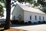
And, on the grounds of the park is a colonial cabin built about 1787 called The Logan Cabin. Very impressive amount of wood chopping on display and some sizeable timbers in its frame.
Leaving Ninety Six the next important stop is Abbeville - a very charming small town - one which I would like to go back and visit. They have a public library there with a wall full of genealogy, notes and diaries.
Headed SW from Abbeville on a broad highway crossing a lot of streams. Did not know it at the time, but we were running north of the line the settlers would have been on. But, we managed to cross the Savannah River on Hwy 72 and found a goldmine that I had no idea existed.
Just after we crossed into GA we found this marker: Intersection of Hwy 72 ( E-W ) which crosses the Savannah River and Bobby Brown State Park Rd ( N-S). Go south on BBSPR to get to Petersburg.
After seven miles you come to Bobby Brown State Park - ( $3 fee) - enter and drive as far as you can going south. We were there in Feb so the part of the park we needed to get to was gated and I had to walk about a half mile.
And found this:

It reads: in 1784 General George Mattews brought a number of Virginians and Carolinians, large tobacco planters to settle this section. Dionysuis Oliver laid out the town of Petersburg o the site of the earlier settlement of Dartmouth, at the union of the Broad and Savannah Rivers and built a large tobacco warehouse. Among the early settlers were Governor William Wyatt Bibb, and Judge Charles Tait, who served together in the US Senate (1813-17), the Shacklefords, and other prominent Huguenot families. Both Petersbrug and the old road to Augusta are now under water.

Information I found about Native American lands and how they were taken by the British. This method was used in China, India, and other countries as well.
This is the end of the road in Bobby Brown State Park.
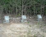
Nearby is a three sided marker:

Hike to the water.
To the right of these and through a fence is a path leading south about ½ mile to the old town site of Petersburg.
Petersburg, GA
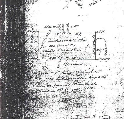
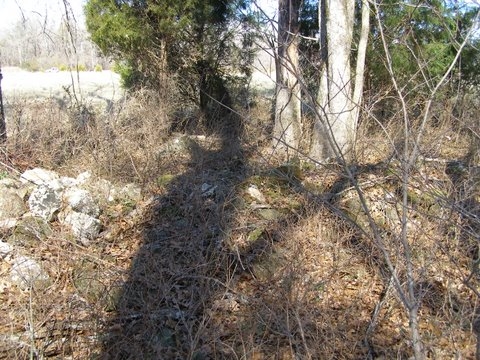
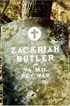
“ A “ on this map is where Zachariah and Patrick are buried. I am not positive if this is the exact same land they owned and farmed, but for now, it seems reasonable to assume it is. “ B” on this map is where they crossed the Savannah River and where the village of Petersburg GA was. At present Zachariah Butler, b. 1736 is the most distant relative on this branch of the family whose grave can be located. His father, Christopher, I assume, is buried near Hanover, VA - but we do not know where.
The map is old, circa 1839
I include it so I can point out the tiny community of Goose Pond.

It is just on the south side of the Broad River and close to Hwy 17
Goose Pond is where Meriwether Lewis’s step-father, Captain Marks, and his mother made their home in GA. I include it because if you look at the next map you see that the Lewis and the Butler families were living in close proximity. Maybe 7 miles apart. Meriwether Lewis lived in this part of GA for about 4 years and his thorough knowledge of how to live in the wilderness was learned in the vicinity of Goose Pond
Not that I am trying to ride the coattails of a famous person, but all the Butler children and grandchildren had the same opportunity. And they did learn. Children of James and Patrick moved on west to establish farms and families in Alabama, Mississippi, Tennessee, Arkansas, Texas and beyond. Today there are thousands of descendents whose very roots go right back to this spot in GA.
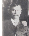
Thanks so much for this contribution Randy! ( Randy Wilson is a descendant of James Butler, oldest son of Zachariah Butler)


 It reads: in 1784 General George Mattews brought a number of Virginians and Carolinians, large tobacco planters to settle this section. Dionysuis Oliver laid out the town of Petersburg o the site of the earlier settlement of Dartmouth, at the union of the Broad and Savannah Rivers and built a large tobacco warehouse. Among the early settlers were Governor William Wyatt Bibb, and Judge Charles Tait, who served together in the US Senate (1813-17), the Shacklefords, and other prominent Huguenot families. Both Petersbrug and the old road to Augusta are now under water.
 Information I found about Native American lands and how they were taken by the British. This method was used in China, India, and other countries as well.


 Hike to the water.